Sign in
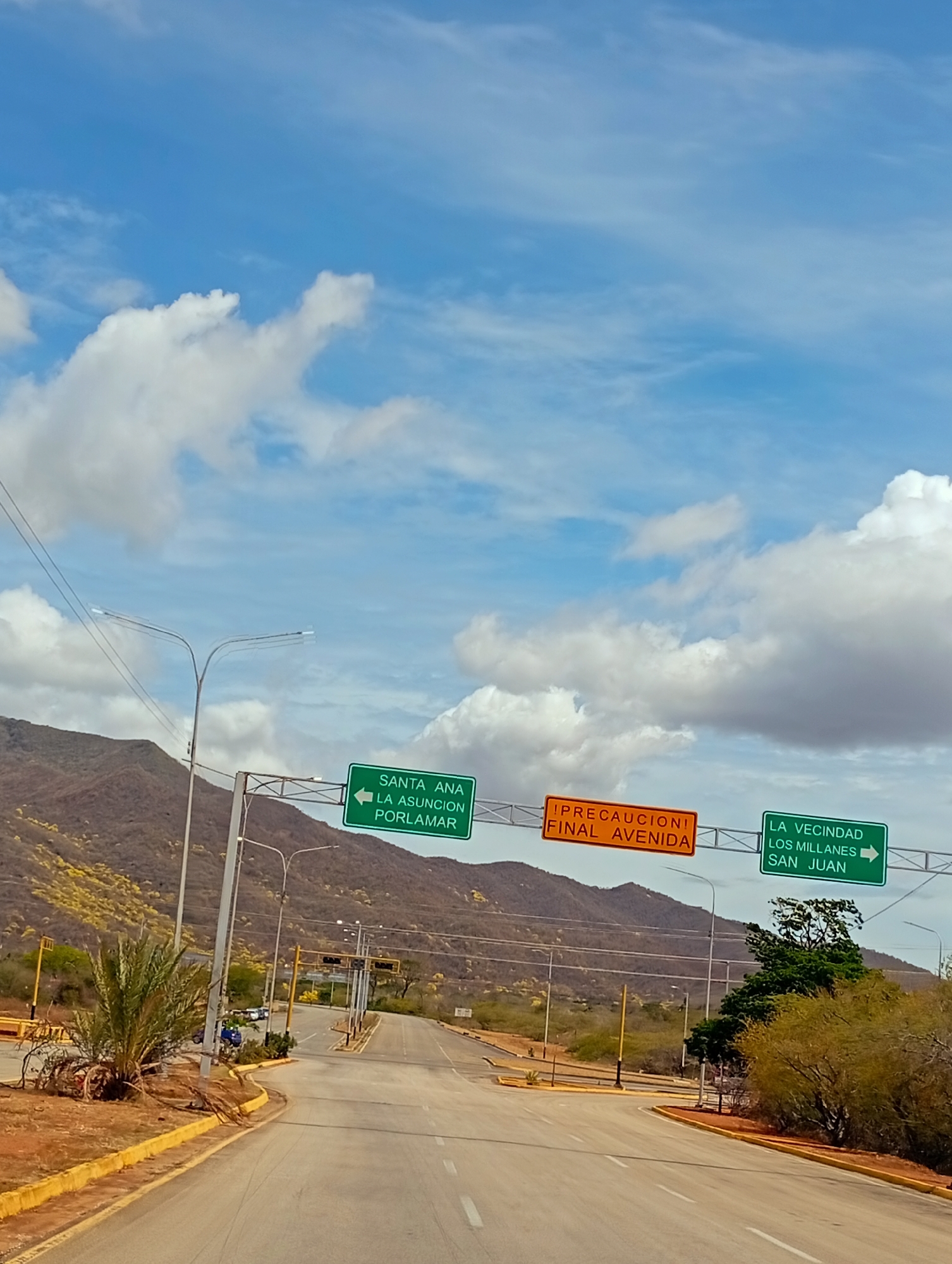
The image displays a sunlit, multi-lane asphalt road at an intersection or major junction, flanked by arid, mountainous terrain under a blue sky with scattered white cumulus clouds. Three overhead signs direct traffic: the leftmost green sign indicates "SANTA ANA," "LA ASUNCION," and "PORLAMAR" with a left arrow; the central orange sign reads "!PRECAUCION! FINAL AVENIDA" (Caution! End of Avenue); and the rightmost green sign indicates "LA VECINDAD," "LOS MILLANES," and "SAN JUAN" with a right arrow. These destinations are located on Margarita Island, Venezuela, suggesting the image captures a point along a primary road (likely the Avenida Juan Bautista Arismendi or Circunvalación Norte) near Santa Ana, specifically at an approach to a significant intersection or the terminus of a major avenue.

The road features yellow curbstones and multiple streetlights with double-arm fixtures. Further down the road, yellow poles with what appear to be dark traffic signals are visible. A large green palm tree occupies the left foreground near the roadside. The background consists of brown hills covered in sparse, dry vegetation, with visible patches of yellow-flowering plants. A single blue car is visible parked or slowly moving on the left side of the road in the middle distance. No individuals are visible. The overall environment suggests a dry, tropical climate.
L
luis

Jun 5, 2026, 5:41 PM

Santa Ana, Venezuela

Moment

Stake attention in this memory

hopeful
adventurous
optimistic
curious
peaceful

The image displays a sunlit, multi-lane asphalt road at an intersection or major junction, flanked by arid, mountainous terrain under a blue sky with scattered white cumulus clouds. Three overhead signs direct traffic: the leftmost green sign indicates "SANTA ANA," "LA ASUNCION," and "PORLAMAR" with a left arrow; the central orange sign reads "!PRECAUCION! FINAL AVENIDA" (Caution! End of Avenue); and the rightmost green sign indicates "LA VECINDAD," "LOS MILLANES," and "SAN JUAN" with a right arrow. These destinations are located on Margarita Island, Venezuela, suggesting the image captures a point along a primary road (likely the Avenida Juan Bautista Arismendi or Circunvalación Norte) near Santa Ana, specifically at an approach to a significant intersection or the terminus of a major avenue. The road features yellow curbstones and multiple streetlights with double-arm fixtures. Further down the road, yellow poles with what appear to be dark traffic signals are visible. A large green palm tree occupies the left foreground near the roadside. The background consists of brown hills covered in sparse, dry vegetation, with visible patches of yellow-flowering plants. A single blue car is visible parked or slowly moving on the left side of the road in the middle distance. No individuals are visible. The overall environment suggests a dry, tropical climate.

Symbol

AF1F6

Volume

0

Creator

+$0.04

Revenue

+$0.00

TVL

$0.00

1D
1W
1M
All

Loading AttnAds…

transactions
revenues
stakers
Earliest
Latest
Highest stake

1

Lili🪷

Staked 1mo ago
Redeemed 1mo ago

$2.90 USD

+$0.03 USD

Fee: $0.01 (0.5%)

+1%

2

Rev Bot 🤖💰

Injected revenue 1mo ago

Revenue bonus for the last stake.

+$0.09 USD

More from this user

More from Santa Ana

Lluis

Jun 5, 2026, 5:41 PM

Santa Ana, Venezuela

Licensed under Creative Commons Attribution 4.0 International License. You are free to share and adapt this content with proper attribution.